A redacted version of my usual ranting on the link between place-making and peace-building was published in today’s Philippine Star as part of its 33rd anniversary special. Some of this comes from talks given at the UrbanisMO session of the 2018 Artkitektura festival, and a few sessions with the Philippine Chevening alumni association.
https://www.google.com.ph/amp/s/www.philstar.com/lifestyle/modern-living/2019/07/27/1938412/urban-reform-philippines-bridging-our-many-divides/amp/
I’m posting the original version here. 🙂
—
Making Space for Peace:
Challenges and Opportunities for Place-making, Peace-Building, and Urban Reform in the Philippines
Ica Fernandez
‘Urban and regional planning’ and ‘peace and development’ are phrases that rarely go hand-in-hand. Planner-architects and engineers dealing with the built environment (hence the professional Philippine discipline of ‘environmental planning’) rarely engage with those tagged as ‘peacebuilders’: that is, lawyer-negotiators, political scientists, and members of the security sector, let alone economists, development workers, orlocal civic organizations. However, this is a false divide, as many of the nation’s fundamental challenges are embedded in its streets and buildings, in the urban fabric of our communities.
There are serious implications when legal and political agreements—ranging from parameters for internal revenue allotments to peace deals to shifts to federal systems of government–are drafted and implemented without clarifying their implications in actual space and place. Similarly, beautifully-rendered designs for projects such revitalising EDSA or reconstructing a bombed-out city, will never become reality unless checked for area-specific political, cultural, and financial issues, and the necessary safeguards built in to address them.Many of the development challenges for the country connect both urban and rural settings, and a more place-based approach can provide an entry-point for developing new and more effective responses to those challenges. For the Philippines to reach its full potential, there is a need for area development that focuses not only on legalities, economic investment, or physical infrastructure, but also includes a full a range of targeted, human-scale processes and designs that can bridge relationships between and amongst people who live, work, and play in the most vulnerable communities.
Part of the problem lies in the misconception that the need for ‘peace–building’ is a niche issue that affects only people in the hinterlands. However, conflict and the social inequality that fuels it is a barrier to the entire country’s full socio-economic potential. The Philippines is one of the most risk-prone countriesin the world. In 2018, it ranked second globally in terms of internal displacement—eighty percent due to natural disasters, and twenty percent due to armed conflict. The country is also home to formal peace negotiations with at least five non-state armed-groups, from the Cordilleras of Northern Luzon to the islands of the Visayas to the marshlands and islands of Mindanao, all of which have roots in historical grievances and narratives of dispossession. While Luzon has historically generated roughly 55% of all economic growth, the poorest regions of CARAGA and the new Bangsamoro Autonomous Region in Muslim Mindanao (BARMM) host the largest armed groups in the archipelago: the Communist Party of the Philippines / New People’s Army / National Democratic Front (popularly known as the NPA), and the Moro Islamic Liberation Front (MILF) and its precursor, the Moro National Liberation Front (MNLF). While the MNLF and MILF have signed peace agreements for the transformation of governance in southern Philippines, the talks with the NPA remain unsuccessful. The same resource-rich yet income-poor areas are home to many indigenous peoples’ groups, who tend to be caught in the crossfire. The protracted, low-intensity and seemingly intractable nature of these localized and multiple conflicts means that social tensions are never fully resolved, and often spills into what is called horizontal conflicts related to political competition and the so-called ‘shadow economy’.
No country with a running subnational conflict such as that experienced in the Philippines for the last six decades has achieved a Sustainable Development Goal. Estimates show that it costs a medium-sized developing country the equivalent of 30 years of GDP growth, and will take at least a generation to reverse. Although poverty is not a direct cause of conflict, it is clear that poverty is a driver of conflict, while conflict exacerbates poverty.
Although these contestations have traditionally been rural in nature, increasing urbanization is making a place-centered approach to peace–building, or a conflict-sensitive approach to place–making, a more urgent issue. At present, half of all Filipinos live in cities. This is projected to reach 84% by 2050. Philippine cities generate 70% of the GDP, of which 36% is generated in Metro Manila alone. Cities are conflictual by their very nature, but the density of people, infrastructure, goods, and services that characterises urban life ensures that the scale of urban violence and insecurity can easily eclipse that of open warfare, with high human and economic costs. This has implications not only on places such as Marawi, Cotabato, or Jolo, but even in areas such as Metro Davao or Metro Manilaitself—which in 2017 was the ranked the 10th most stressful city in the world, and the only one on the list without a traditional civil war. Although urban poverty incidence (12.5%) was less than half of the national poverty incidence (25.2%) in 2012, cities remain sites of deep and multidimensional poverty, where crushing traffic jams occur just outside closed-off subdivisions and gated communities sitting cheek-by–jowl against sprawling slums. In this light, armed conflicts—which translates in Tagalog as ‘hidwaan’, or separation—are just more dramatic reflections of the kind of disconnections we deal with on a day-to-day basis, or why our current systems of transportation,education, housing, health, livelihood, culture, and yes, politics, don’t seem to reflect our most fundamental needs and realities.
So what can be done to connect and not divide? Much of the established conflict economics toolkits are at the national, regional, and provincial levels (which are crucial for strategic planning), but the nuances of these areas can be best understood and therefore implemented at the level of the city and the architectural shape of neighborhoods, in the praxis of what people in cities do. This means combining the toolkits of both peace–building and urban design to encourage healthy spaces and linkages between economically lagging and leading areas. This means national policies that allow for regional and provincial and local integration, while dealing with the specific challenges of each place.
For people in working as urban planners, engineers, or architects, this means shifting from the dominant Philippine misconception of spatial planning as a purely technocratic or physical design exercise but something closer to what scholars describe as ‘place-governance’. As written by Mumford in 1938, cities are the ‘point of maximum concentration for the power and culture of a community,’ and that one of the chief functions of the city is to ‘convert power into form.’ Part of this is acknowledging that the state of our cities, its design and infrastructure is but a reflection of social realities. Whileplanning at its best can and should be a tool for inclusive economic growth and redistributive justice, it is often complicit in the power structures that propagate inequalities themselves.
A useful guidephrase is ‘conflict-sensitivity’, which is operationally defined as a contextual understanding of the conflict topography unique to a given area that should inform programs and project interventions. It is a term typically used in tandem with the principle of ‘do no harm’, meaning that development decisions should not cause further damage to a community or a society that has been ravaged by conflict. This highlights that there are no ‘one-size-fits-all’ solutions, and so interventions must be nuanced based on the specific drivers and challenges in the area.
This asks for a multi-dimensional, multi-sectoral framework, not sectoral silos, which will then be grounded in space and place. An approach with a place-governance lens demands a balance between both short-term confidence-building requirements and long–term broad developmental outcomes, which cannot be limited by traditional three-year political terms. Similarly, this means that culture and identity is not just a question of aesthetic design, but asks how people use places and spaces to live, work, and play.
This also means gradually building a homegrown conception of Philippine archipelagic urban politics, given that the planning concepts and land ownership laws presently in use and taught in schools are legacies of our Spanish and American colonial pasts. As shown in our car-centric transport system, these foreign models are often stacked towards the middle-class and upper-middle class. The Philippines has no national urban or general land use policy or plan, and is hampered by fractured institutional authorities and disjointed coordination and integration amongst city, province, and national administrations.
Whilst Environmental Planning is licensed by the Professional Regulation Commission, few local governments have trained personnel that are able to harness the various interdisciplinary inputs required for effective urban planning and design. An average city planning officer is tasked to draft at least a dozen area and sectoral plans, despite attempts by the Department of Interior and Local Government, the Housing and Land Use Regulatory Board (soon to be transformed into the Department of Human Settlements), and the National Economic and Development Authority (NEDA) to harmonise and simplify these processes. Very few institutions, whether public, private, or academic, are able to provide adequate training, let alone generate policy options for decision-makers. As such, many planning processes end up as checklist exercises for compliance; cut-and-paste CLUPs and CDPs are not unusual. Although community consultation is a requirement for local planning processes, meaningful participation in urbanization–particularly of the most marginalized and vulnerable–remains to be fully realized.
A peace–building approach to place-making means thatdevelopment is not just delivering hard infrastructure, but designing processes that can build confidence and stability and promote ‘social cohesion’, or what is defined as the “norms, values, and social relations that bond communities together, as well as form bridges between communal groups and the state”.This is important in the implementation of peace agreement themselves, which have major components related to land, housing, and property. It is equally important when dealing with informal settler families and small-scale vendors in cities, whotraditional development paradigms dismiss as eyesores although global evidence now acknowledges the major role of the so-called informal economy in driving the engines of growth.
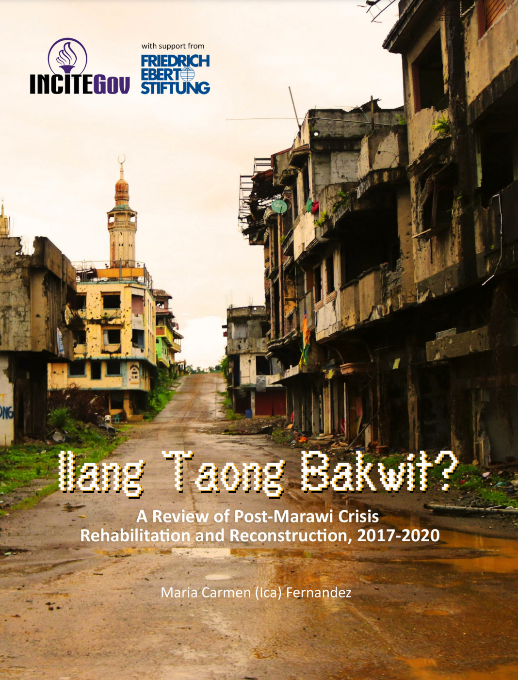
The unfinished talks with the CPP/NPA/NDFP should have led to the drafting of the so-called CASER, or a Comprehensive Agreement on Socio-Economic Reforms, which includes substantive provisions on agrarian reform, ancestral land, environmental protection, and industrialization. The GPH-MILF Comprehensive Agreement on the Bangsamoro acknowledges the historical marginalization and land dispossession of the non-Christianized peoples of the region, and guarantees the area development of six major camps of the MILF, as well as the potential provision of programs such as housing for demobilized former combatants. Again, these issues cannot be seen from just a counterinsurgent or physical infrastructure lens—we forget atour peril that these mujahideen and mujahidat did not fight for handouts or raw concrete, but something much more dignified.The major place-making-as-peace-building challenge of the last five years, however, is the 250–hectares of destroyed urban corein the Islamic City of Marawi, and the fundamental request of residents for government to finish clearing bombs and unexploded ordinance to allow them to finally go home.
A place-governance approach does not necessarily require separate urbanization programs. Place-governance involves lenses and principles that can be applied to pre-existing economic and social development initiatives, encouraging a shift from place-breaking to a place-making culture. There are a number of options for engagement, which can be with regional governments such as the BARMM or direct with local governments at the provincial, municipal, and barangay levels; national and regional agencies and instrumentalities; and most especially, engaging the private sector, the academe, and home-owners and community members everywhere. Part of the challenge of urban policy reform is attitudinal; because it’s seen as too large, difficult, or abstract to engage. What will be needed is grounding this perspective in very targeted programs, allowing local stakeholders to have a clear and personal stake.
At its core, the toolkit for place-making for peace-building is driven by two things: ensuring connections, not divisions, and “dealing with the past”, or the things that make people hurt and angry—in tangible form. It also hearkens back in many ways to the model of peace-building as a spiritual and ethical act, particularly to the root work of religion, re-ligiere, which means reconnection. It is not about dogma or right or wrong, butbringing together what has been severed. By helping design and strengthen processes that can support sustainable and inclusive places, we may ripen to models of local governance and place-leadership that can bridge our many divides.